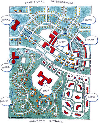
The 13 points of pedestrian-oriented development

Here they are as presented by one of the top town planning firms in the country, Duany Plater-Zyberk & Company. The diagram shows an auto-oriented sprawl infrastructure in the lower half – notice how each major destination leads to a ‘collector road’ – a major source of traffic congestion. The pedestrian-oriented layout in the upper half (aka traditional neighborhood development (TND), aka ‘good suburban development’) shows how traffic is distributed evenly with multiple choices of travel, though the housing is depicted as predominantly single-family for communication purposes. The 13 points:
1. The neighborhood has a discernible center. This is often a square or a green and sometimes a busy or memorable street corner. A transit stop would be located at this center.
2. Most of the dwellings are within a five-minute walk of the center, an average of roughly 2,000 feet.
3. There are a variety of dwelling types – usually houses, rowhouses and apartments – so that younger and older people, singles and families, the poor and the wealthy may find places to live.
4. At the edge of the neighborhood, there are shops and workplaces (and/or transit stations leading to workplaces) of sufficiently varied types to supply the weekly needs of a household. (Collective neighborhood edges form a town center.)
5. An elementary school is close enough so that most children can walk from their home.
6. There are small playgrounds accessible to every dwelling – not more than a tenth of a mile away.
7. Streets within the neighborhood form a “connected network, which disperses traffic by providing a variety of pedestrian and vehicular routes to any destination.
8. The streets are relatively narrow and shaded by rows of trees. This slows traffic, creating an environment suitable for pedestrians and bicycles.
9. Buildings in the neighborhood center are placed close to the street, creating a well-defined outdoor room.
10. Parking lots and garage doors rarely front the street. Parking is relegated to the rear of buildings, usually accessed by alleys.
11. Certain prominent sites at the termination of street vistas or in the neighborhood center are reserved for civic buildings. These provide sites for community meetings, education, and religious or cultural activities.
12. The neighborhood is organized to be self-governing. A formal association debates and decides matters of maintenance, security, and physical change. Taxation is the responsibility of the larger community.
13. For single-family homes: A small ancillary building is permitted within the backyard of each house. It may be used as a rental unit or place to work (e.g., office or craft workshop).

Thats all good in a perfect world, but how many people can find a good job within walking distance of their home. Also, not that many people can afford to live in a community like this or that close to their job, especially in California.
Thanks for the comment, I edited #4 to clarify that access to work is just as important (and usually more realistic), which is something I previously discussed with the author.
If a place isn’t affordable like in California, one major reason is that the supply can’t mean the demand, and a predominance of single-family subdivisions over multi-family doesn’t help, especially when land is scarce. The City of SF is expensive because there simply aren’t enough of them.
That’s the irony – that these places are expensive. There is no reason they should be except that most developer’s are either to myopic or too scared to do anything that deviates from the status quo. Also ironic – strict zoning laws can actually make the problem worse by stifiling what developers can do.
Besides the street pattern not much is different between the two plans. Distances between uses are the same and multi-family is used to buffer the single family homes from annoyances like street noise-perpetuating peoples attraction to single family homes. Try mixing some of the attached units into the single family homes. This may provide an opportunity to include some other uses (retail – coffee shop) closer to more people.
Excellent point – and therein lies some of the criticism for new urbanism – most of the press is about these ‘new suburbanism’ types of developments that really aren’t what this target market is looking for. The great thing about the layout in the upper half of the diagram is that it can actually scale down to a fourth the size, or four times as dense, which would then make it truly walkable. The lower layout cannot.
I search for a long time, finally I find an affordable appartament near my job. After a short period of acommodatión whith the neighbourhood, now I walk to work and is the most enjoyable thing. I won at least five hours a week to myself. Just to encourage the pedestrian development. Gmo.