
Graphically speaking, how affordable are city centers?
How affordable are central cities? In a quarterly newsletter by Reconnecting America’s Center for Transit Oriented Development, this is answered statistically.
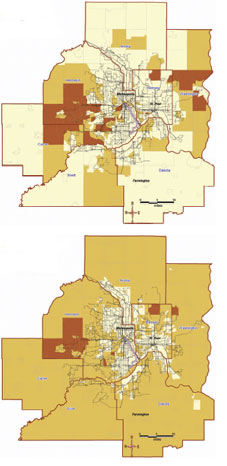
The map on top shows the areas in Twin Cities, MN that are affordable in the lightest color, when only housing costs are factored in. The darker areas are less affordable (greater % of income spent on housing), and the darkest areas are least affordable.
The map below shows what happens when transportation costs (e.g. car ownership, gas, transit) are added in addition to housing. As you can see, the people living in the center area spend the least amount on housing and transportation as a % of income, since many of them walk and don’t have auto-oriented expenses.
Why should a city care about supporting city and neighborhood centers as far as job creation goes? As stated yesterday and repeatedly on this website, affordability is one of the best assets cities can have in attracting creative, enterpreneurial people and businesses.
The map is a vivid example of how a picture is worth a thousand words, or perhaps to home seekers, thousands of dollars.
Leave a Reply